First of all, apologies for missing my self-imposed deadline to have a fresh blog posted every Sunday morning. I have no excuse, except perhaps for the fact that I had a bit of getting ready to do for my trip home to Canada for Christmas. In truth, that didn't really take a whole lot of time, but getting here was time-consuming and distracting. For instance, I had to take THREE different flights (London to Newark, Newark to Denver and Denver to Saskatoon), making for the longest Thursday ever. I can't believe that was the best combination of flight times and price.
On the plus side: Because I was forced to be conscious for about 24 hours straight, I had the time to stare at the crossword until I actually finished it, despite the fact that it fought back every step of the way. Also, I ALMOST finished the Telegraph Toughie crossword which I have never even come close to cracking before. And I don't even feel badly about missing those last two clues because I later found out that one of the answers was SPILIKINS which... what the Hell? Is that even English?
Then again, on the minus side: On the Newark to Denver leg of the trip I ended up sitting in between a man and a woman who were both of the species Mobilis Textus Addicticus, and were texting the whole time we were sitting on the plane waiting to push off. When the announcement came that it was time to turn off all phones, I suppose I misheard because they actually must have said "All phones except for you people in Row 26, who can keep texting for as long as you want because you are SPECIAL." Honestly, we were actually taxiing down the runway and these people were still at it. At one point I almost leaned over to Mr. 26D and said, "Look buddy, unless you are actually talking someone through an emergency appendectomy via text message, TURN OFF THE FREAKIN' PHONE." Why are people so stupid?
But none of that has anything to do with the topic of today's blog which is another in our series about recreational past times. Today, we're walking. However, I'm not talking about normal, boring, every day walking - the kind of self-propelled movement of oneself to the pub or bus stop or corner shop. What I'm talking about is sometimes referred to here as "rambling" and is about striking out across the countryside in a pair of stout boots to tromp through muddy fields and up hills and past sheep. (We'd generally call this hiking in North America.) After my pleasant walk along the Devon coastline with Anne a few weeks ago, I decided it might be enjoyable to try some longer walks on my own, especially since I've got the time for this sort of thing right now. Luckily, Google quickly directed me to the website of the Saturday Walkers Club which was so perfectly suited to my needs it's a bit astonishing. Their website boasts a collection of more than 160 different walks in the south of England, each of which is easily accesible from London by public transport, meticulously documented with directions and maps, and crafted to take one past a convivial rural pub at about lunch time and somewhere for a cup of tea at the end. All for free.
Rambling is apparently the most popular outdoor recreational activity in England, and I can understand why. The country is perfectly suited to it. First of all, the place is TINY. If I tried to go for a nice ten mile walk here in Saskatchewan I might manage to make it from one farmer's property to the next and could hope to see, er, some wheat, and perhaps some more wheat. In England ten miles takes you through dozens of small fields, up and down hills, through woods, alongside rivers, into and out of three or four tiny villages, past a couple of medieval-era churches, perhaps near a castle or a country estate and to so many ridiculously picturesque viewpoints it's, well, ridiculous.
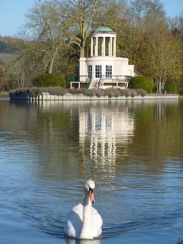
See what I mean? This is the ornamental folly on Temple Island, at Henley-on-Thames, which astute fans of the Olympic Opening Ceremony may remember from the show's opening sequence. Nice bird too.
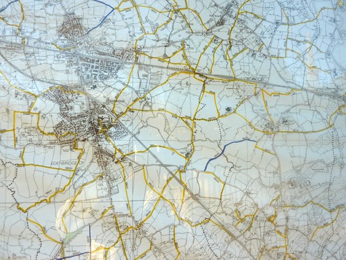
This is a photo I took of a map of a corner of countryside near Hever Castle in Kent. Everything lined in yellow is a public footpath. As you can see there are rather a lot of paths shown, and this is a vanishingly tiny bit of the country.
I was a bit nervous about the whole thing, but I needn't have worried. First of all, you're never far from help in rural Kent - it's not exactly Scott-of-the-Antarctic territory. And really, the walking club directions really are exemplary. Here's an excerpt from that first walk, to give you an idea of their meticulous detail:
"In 180 metres at the valley bottom go through a wooden kissing gate as the footpath starts to ascend. After 120 metres go through a metal kissing gate and up into a wood. In 80 metres at a path T-junction turn half-right up a bridleway. After 45 metres ignore a footpath to the left and continue through what is now a wooded field border." (Knockholt Circular Walk number 7)It is generally pretty hard to go wrong, and quite fun to come up over a hill and be able to see the next fence, wood or gate, exactly where it's supposed to be. It's a bit like a scavenger hunt, and is immensely satisfying. And, on the rare occasions when the directions were not crystal clear, I usually had enough signal on my phone to call up the map on the website to double check, or even use the compass app to confirm my heading. All in all, the system works really well, especially is you're able to recognise a few key types of landmark such as:
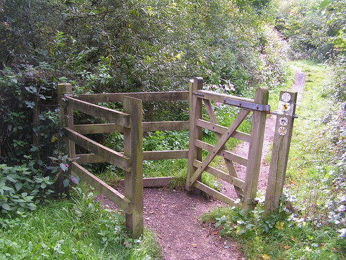
A typical kissing gate, a way of keeping a field closed to livestock or motorised vehicles, but open to walkers, without having to rely on someone to close the gate.
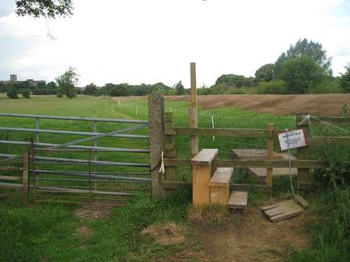
A stile, which comes in many forms and is simply a way of helping people climb over a fence. This one has a little hatch to the right to allow dogs to pass through.
A squeeze gate, another way of keeping livestock corralled while allowing walkers to squeeze through the tapered gap in the middle. This one also shows the helpful yellow flags that indicate public rights of way and the green "walking man" signpost that's a dead giveaway. Also: sheep!
Here's a look at what the OS map for part of my Knockholt walk looks like. The green highlighted line is the route of the walk. These OS maps are really just fantastic - they're so detailed that individual buildings are shown. And how can you not love a country with places like "Pratt's Bottom" and "Birthday Wood"?
As Bill Bryson writes in "Notes from a Small Island", on the subject of the wonderfulness of Ordnance Survey maps:
"As a rule, I am not terribly comfortable with any map that doesn't have a You-Are-Here arrow on it somewhere, but the Ordnance Survey maps are in a league of their own. Coming from a country where mapmakers tend to exclude any landscape feature smaller than, say, Pike's Peak, I am constantly impressed by the richness of detail on the OS 1:25,000 series. They include every wrinkle and divot of the landscape, every barn, milestone, wind pump and tumulus. They distinguish between sand pits and gravel pits and between power lines strung from pylons and power lines strung from poles. This one even included the stone seat on which I sat now. It astounds me to be able to look at a map and know to the square metre where my buttocks are deployed."Despite the lack of an OS map, I managed to finish that first walk successfully, though I did have to jog the last mile or so in order to get back to the train station before simultaneously losing the daylight and missing the train.
My shoes, after 12 miles of puddles and mud. The picture doesn't really properly portray the comprehensive muddiness and toe-wrinkling wetness. I have since invested in a pair of inexpensive but waterproof walking boots which, despite the conventional wisdom that cheap boots are a false economy that will quickly lead to blisters and tears, have performed perfectly and carried me through a lot of November mud.
Since that first walk, I completed a lovely Sunday afternoon ramble at Henley, which included a nice section through the Great Wood and ended at a place called the Chocolate Theatre Café. (It's like they knew I was coming. Even better, it was just around the corner from the "London Real Ale Harry Potter Marmite and Cheese Double Decker Bus Free Wifi Pub".) I also did a nice walk from Chorleywood to Chesham, though the day was quite hazy so I was forever reading directions that said something like "Follow the path up the hill with the field on your right, not forgetting to turn around at the top to take in the stunning view of the Chess River Valley" which turned out, in my case, to be rather underwhelming sea of grey. Though it did make for a nice series of shots of a lonely tree in the middle of a field:
Much friendlier.
God, I need a job...

Another of the picturesque shots that come a dime-a-dozen on a typical walk.
P.S. More pictures from my various walks can be found at Flickr, in the set called "Rambling"


1 Comment:
Gosh, rambling sounds so wonderful! Hope you continue to enjoy it ... expecially the nice cups of tea at the end.
-Em
Post a Comment